Well, we’re back home now. We made a mad dash two days early, April 2, to avoid snow and ice storms coming down from the north.

After 3 and 1/2 weeks following the Mississippi to the bottom of Louisiana and back up, I know a lot more about this river that, if stretched out, would reach from east to west coasts across the US and drains 40% of the rivers in the lower 48.
For example:
- the difference between a bayou, a swamp and a marsh;
- what a spillway does;
- how all that Spanish moss that drapes down the trees in the swamps can be used and who harvests it;
- how to pronounce Atchafalaya swamp (“ like a sneeze”) and why it’s so important to Louisiana;
- all about the great flood of 1927 and its causes;
- Herbert Hoover’s flood rescue and the original fake news;
- who stopped the levees breaking then and who cleaned up (Black);
- who got rescued first or at all (White);
- what the current 10 year Master Plan is for land recovery and flood control in Louisiana;
- who is leading this effort and what new groovy tools they have to model the BMPs (best management practices);
- Where the Mississippi wants to go and who and why they are trying to stop it.
But rather than a Wikipedia entry, I will tell a story about where we went, who we talked to, and what we soaked up—so to speak—in the process of having a great time. For more detail on some of the complex issues and history, I include links to some of the more interesting and informative sources I found.
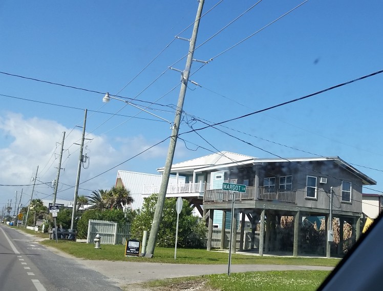
Chapter 2 of our Big Muddy Meander left us in Patterson, LA, in the Atchafalaya Basin and Bayou Teche, not far from the Gulf of Mexico, and part of Acadiana. There seems to be some difference among the locals as to whether the large slow river along the city’s edge is Bayou Teche or the lower Atchafalaya River. The former flows into the latter. Since we brought our kayaks on the trip, we wanted to get out there into all the water we were seeing on our way down. To get us started, we contacted a canoe/kayak service in Breaux Bridge, just beyond the Cajun city of Lafayette an hour away from Patterson. Cory Werk, the owner of Bayou Teche Experience, proposed an eight mile paddle in a section of the newly designated a National Water Trail, which is 135 miles long. He rode with us to the start of the section and then drove our car back to the dock by his shop.  The trail is a mix of developed edges and swamp edges, with plenty of sightings of herons, egret, turtles, and one snake. No alligators. Still too cold and faster moving than they prefer.
In chatting at the end of the paddle with Cory, who promotes an ecological approach to the area and its pleasures, he recommended we read a book called Rising Tide, by John Barry. It’s the award-winning story of the Mississippi River’s great flood of 1927, published in 1999. We immediately got the audio version and started listening to it as we drove around Louisiana. The epicenter of the flood was in Greenville, MS, in the Delta. We were fascinated as Barry moved back and forth in time from the horror of the flood itself to the clash of engineers and politicians over the proper approach to controlling the annual and sometimes catastrophic spring floodwaters prior to 1927, and then to the lessons learned and post- flood changes. Also new to me was the effect of the flood on the majority African American population, who served as the primary agricultural labor force in the Mississippi Delta. After being press-ganged at gunpoint to the levees to sandbag as the water rose, refused evacuation for fear of losing that labor force by the White plantation owners, and press-ganged again to handle the post flood clean up work, the largest mass migration took place north to Chicago. And that was the origin of the Chicago Blues.
There are many great resources on the flood, as well as great songs and vintage photos. I recommend the reader check out some of these:
1. Randy Newman Louisiana 1927. Great music and vintage photos.
2. These YouTube videos show two views of the heroes of the flood. The first is a history lesson by a local teacher called the Real Story. The second is a propaganda film from the Herbert Hoover presidential campaign. Note that they say only 6 people died as a result of his valiant efforts. This is 250 less than the number most agree on. Compare what the first says about the role of Black people in fighting the flood. Note the absence of Black people mostly from the film. John Barry’s book supports the first video.
3. This article in Black Past.com details how Blacks in Mississippi were treated as chattel long after the end of the Civil War during and after the flood.
John Barry has become a flood and flood protection expert since writing Rising Tide. After Hurricane Katrina in 2005, Barry was appointed to the board overseeing the recovery and abatement plan. He soon became disenchanted with the less-than-enough recommendations and the lack of interest by then governor Bobbie Jindal in funding any part of the plan with state dollars. In 2013 he filed a lawsuit against 97 oil and gas industries working in the wetlands below New Orleans to recover at least part of the $36 million the companies had accepted as their responsibility in the disaster. This NYT Magazine article does a great job of explaining the details, along with all the Sturm und Drang surrounding the response by the oil and gas industry and their political allies.
After Patterson, we headed down to the Grand Isle State Park, which is located on one of the barrier islands between the Gulf and the ever decreasing Louisiana coast. The trip offered a pictorial of the forces at work in losing a football field of land to the ocean every hour. We drove through some small towns in the Louisiana delta on our way to the bridge to Grand Isle, passing new grand home after new grand home. Where was that money coming from, and why here?  As we dropped into the marshlands we saw miles of marshy water with dozens of floating oil rigs. Maps in the NYT article show the before and afters of the receding marshes and island land mass that serve to hold onto the silt coming down the Mississippi that produces land. Canals dug through these marshes to gain access to the drills and take the products out to refineries remove marshland. It’s the combination of silt run off and rising Gulf waters due to melting ice that create an existential threat to the economy, ecology and people of Louisiana.
 In the meantime, Grand Isle is full of what Cajuns call camps and Minnesotans call lake cabins for beach enjoyment. They are mostly built at least one story off the ground. The Park is small and lovely for camping before the summer comes and the mosquitos swarm. They are very fond down there of the pirate Jean Lafitte who operated out of Barataria Bay. Kind of a Rhett Butler character, who helped defend New Orleans from British invasion in the War of 1812, in between helping himself to whatever he could plunder.
  We kayaked around the Barataria Bay and ventured out away from the breakwaters. We were lucky enough to spy a dolphin pod about 40 feet from us, so we followed them out until they outswam us. After getting our fill of pelicans, gulls of various kinds, shore birds, and beachcombing, we headed back up into Cajun country to an Airbnb in Lafayette.
Besides sampling roots music and Acadian culture, we met up once more with Cory the canoe outfitter. He had suggested a sunset kayak in Lake Martin, a large swamp and preserve owned by the Nature Conservancy in the Atchafalaya Basin. Wow! One of the highlights of our trip.
Skip the swamp boats with motors and large groups if you can. Our four kayaks were ideal for gliding silently among the trees and floating biota, hunting for alligators, birds and turtles. Sunset is when the thousands of birds who nest in the swamp come back to the rookery and alligators sun themselves on floating logs or just above the water line, grabbing that last bit of warmth before dark. Roseate spoonbills!! Anhingas! Egrets and herons! Unknown ducks, Mexican ducks! We pulled into shore just after full dark and dashed our boats back onto our roof rack as the mosquitos began to swarm.
 On our last day before leaving Louisiana we drove east from Lafayette to our appointment in Baton Rouge with Joseph McClatchy, staff at the Coastal Protection and Resource Authority (CPRA). CPRA is tasked with implementing the 10 year Master Plan for a Sustainable Coast. What we were most excited about was seeing the new 3D model of the Mississippi and its tributaries which is as large as two football fields!
 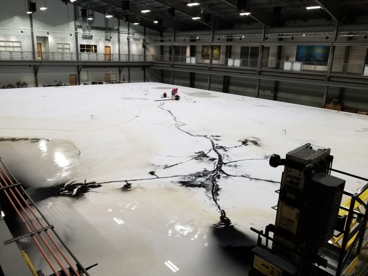 It did not disappoint. It is a scale model, with some adjustment for the depth vs. the length and width, to give adequate depth for the experiment. At the time of our visit, they had just completed running water and hi-tech “silt” down the Mississippi under certain conditions. A graduate student in mechanical engineering was painstakingly vacuuming up all the very expensive “silt” so it could be reused. For someone like me playing in the sandbox of water stewardship in the West Metro (Minneapolis and western suburbs), it was PHD level and astounding. We spent 90 minutes reading all the displays, taking pictures and asking questions of Joseph. Just outside the building along the eastern banks of the real river, the water roiled and rose, trying to exact its will, as it has done for millennia, against the hopes and determination of humans.
The ten types of water management project to be implemented, pending an enormous amount of funding, are these:
- Structural protection (such as miles of levees)
- Nonstructural risk reduction (houses on stilts)
- Oyster barrier reef (I would gladly contribute my share of empty oyster shells!)
- Ridge restoration (after many have been washed away and trees cut down)
- Shoreline protection (to control erosion)
- Barrier island restoration
- Marsh (re)creation
- Sediment diversion
- Hydrologic restoration (dams, locks and spillways)
- Infrastructure (such as the 20 mile bridge across the Atchafalaya swamp below)

Various sources of money have been raised, including a minimum of $5 billion from the BP oil spill for Louisiana overall restoration, but much more remains to be found, including what role the GOP dominated federal government is willing to play. Under the post-Bobbie Jindal era, Louisiana and the new governor John Bel Edwards and many of the power elite in the state have rallied behind the Plan, because it is seen not as an environmental project, but as a counter to the threat to the vital economy of New Orleans and the delta oil and gas industry. No money has so far come from the 97 oil and gas companies in the John Barry lawsuit who are contributing to the state’s ebb and vulnerability. This PBS discussion, including John Barry, describes the pros and cons of the 10 year plan.
According to the New York Times Magazine story “Barry concluded that just as in 1927, people died because of cynical decisions made by shortsighted politicians drawing on bad science. For Barry, Hurricane Katrina was not the story of a natural disaster; it was a story of politics, science and power.”
We left the CPRA to find a spot for lunch near the Louisiana State university campus, with our heads full of the history, science, politics, and ecology of Big Muddy. We sat down and shortly a young man came to our booth and announced “My name is Noah, and I will be your waiter today.” WTF!!
